The difference in soil response between a site on the east side near the Hueco Bolson and one in the Franklin Mountains foothills can shift your site class by two whole categories, and that gap translates directly into foundation costs. El Paso sits on a deep basin fill of unconsolidated sediments—over 1,500 feet of alluvial material in some areas—bounded by exposed bedrock, so assuming uniform stiffness from one parcel to the next is a budgeting mistake we see contractors make more often than they should. MASW testing maps the actual shear wave velocity profile beneath the footprint, delivering a VS30 value that the structural engineer plugs into the IBC and ASCE 7 tables without relying on conservative default assumptions. We pair the multichannel array with a 24-channel seismograph and 4.5 Hz geophones to capture dispersion data from the surface down to 30 meters, then invert it through a solid iterative algorithm that resolves velocity layering even where impedance contrasts are subtle. For sites near the Rio Grande floodplain, where shallow water and soft silts complicate the velocity model, combining the MASW line with a CPT test gives us the continuous tip resistance profile needed to cross-validate the shear wave picks against measured soil behavior rather than modeled estimates alone.
A VS30 of 260 m/s versus 380 m/s can shift seismic base shear by over 30% under ASCE 7—the difference between a mat foundation and deep piles on the same lot.
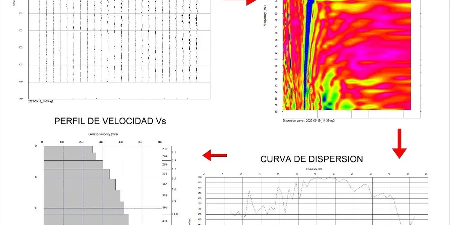
Methodology and scope
Local considerations
A 24-channel Geometrics Geode seismograph with a spread of 24 vertical geophones planted across a graded pad looks deceptively simple from a distance, but the risk sits in what happens when the dispersion image is misinterpreted by someone who treats the fundamental mode as a given. In the stratified basin deposits underlying much of El Paso—think interbedded sands, clays, and gravels from ancestral Rio Grande aggradation—higher-mode energy can dominate the recorded wavefield at certain frequencies, and picking the wrong branch of the dispersion curve injects velocity errors that propagate straight into the VS30 calculation. We run forward modeling on every line to verify that the picked dispersion matches a physically plausible velocity model, and we reject any inversion where the misfit exceeds 5% of the observed phase velocities. A second risk is spatial aliasing when the array is too coarse for the site: on small commercial lots where we are forced to a 1-meter geophone spacing, the Nyquist wavenumber clips high-frequency information above roughly 50 Hz, which matters if the upper 5 meters contain a stiff caliche layer that controls the site period. We flag those limitations in the report and recommend complementary downhole measurements when the uncertainty envelope is too wide for the structural design.
Explanatory video
Applicable standards
ASTM D4428/D4428M-14: Standard Test Methods for Crosshole Seismic Testing (surface-wave adaptation for VS profiling), ASCE/SEI 7-22 Section 20.4: Site Classification Procedure for Seismic Design (VS30-based site classes A–F), IBC 2021 Section 1613: Earthquake Loads — site class determination via shear wave velocity, NEHRP Recommended Seismic Provisions (FEMA P-2082): site amplification factors tied to VS30
Associated technical services
VS30 Site Classification Package
Full MASW acquisition, dispersion analysis, inversion modeling, and a signed report with the VS30 value, NEHRP site class, and the 1D shear wave velocity profile. We include the raw field records and processing files so the structural engineer can review the dispersion picks independently. Suitable for new commercial buildings, school projects under DSA review, and retrofit designs where the existing geotechnical report predates the current ASCE 7 site class framework.
Combined Geophysical-Geotechnical Investigation
MASW line integrated with SPT borings or CPT soundings on the same grid. We correlate the shear wave velocity profile against N-values or tip resistance to build a site-specific velocity-strength relationship, which tightens the uncertainty on liquefaction triggering analyses and lets the foundation designer optimize the ground improvement scope instead of defaulting to conservative assumptions that drive up the construction budget.
Typical parameters
Frequently asked questions
What does a MASW survey in El Paso typically cost for a standard commercial lot?
For a single MASW line with full VS30 reporting on a standard commercial lot in the El Paso area, the cost ranges from approximately US$1,880 to US$3,330 depending on site access, array length required, and whether additional lines are needed for spatial variability assessment. Sites with difficult surface conditions or limited access may fall toward the upper end of that range.
How does MASW compare to downhole or crosshole seismic methods for site classification?
MASW is a non-invasive surface method that measures VS30 without drilling a borehole, which makes it faster and less disruptive than downhole or crosshole testing. The trade-off is vertical resolution: downhole methods give a sharper velocity profile at the exact borehole location, while MASW averages over the array length and can miss thin low-velocity layers. For El Paso basin sites with gradual velocity transitions, MASW resolution is usually sufficient for ASCE 7 site classification.
How long does it take to get results from a MASW survey?
Field acquisition for a single MASW line typically takes two to three hours on site, including array layout, geophone calibration, and multiple shot records. Processing and inversion are completed in the office within three to five business days, and the final signed report with the VS30 value and NEHRP site class is delivered in PDF format. Rush turnaround can be arranged when the structural design schedule demands it.
Can MASW be performed on paved surfaces or inside existing buildings?
MASW requires direct geophone coupling to the ground surface, so paved areas need to have the geophones planted in soil adjacent to the pavement or through cored holes. Inside existing buildings, the method is generally not feasible because the rigid floor slab alters the dispersion characteristics and the confined space limits the array length. In those situations we recommend downhole seismic testing through a borehole drilled outside the footprint.
What site class is most common in El Paso, and how does it affect structural design?
Much of the developed area in El Paso overlying the Hueco Bolson basin fill falls into Site Class C or D depending on the depth to stiffer material and the VS30 value measured. Site Class D sites, with VS30 between 180 and 260 m/s, attract higher seismic design coefficients under ASCE 7 than the default Site Class C often assumed in preliminary design, which can increase the lateral force demands on the structure by 20 to 40 percent. A measured VS30 value replaces the conservative default and often recovers that margin.