El Paso started spreading across the Rio Grande Valley and up the bajadas of the Franklin Mountains long before modern seismic codes existed. A lot of the older infrastructure downtown and in neighborhoods like Segundo Barrio sits on Holocene alluvium—loose sands and silts washed down from the mountains over thousands of years. Our lab team sees these samples every week, and the grain-size distribution curves often raise immediate liquefaction flags. When the 1917 Bavispe earthquake shook the region, it rattled buildings in El Paso and reminded engineers that the city is not immune to distant strong ground motion. Today, a proper soil liquefaction analysis starts with high-quality undisturbed samples and accurate SPT blow counts from the field, but the real interpretation happens inside the laboratory. We run the physical tests that feed into simplified procedures, making sure the cyclic stress ratio calculations rest on solid data rather than generic correlations pulled from a textbook. For deeper alluvial profiles near the river, we frequently pair the screening with grain-size distribution curves to identify gap-graded soils prone to sudden pore-pressure spikes.
Liquefaction is not a yes-or-no switch—it is a performance curve that changes with every 5 percent shift in fines content and every foot of groundwater fluctuation.
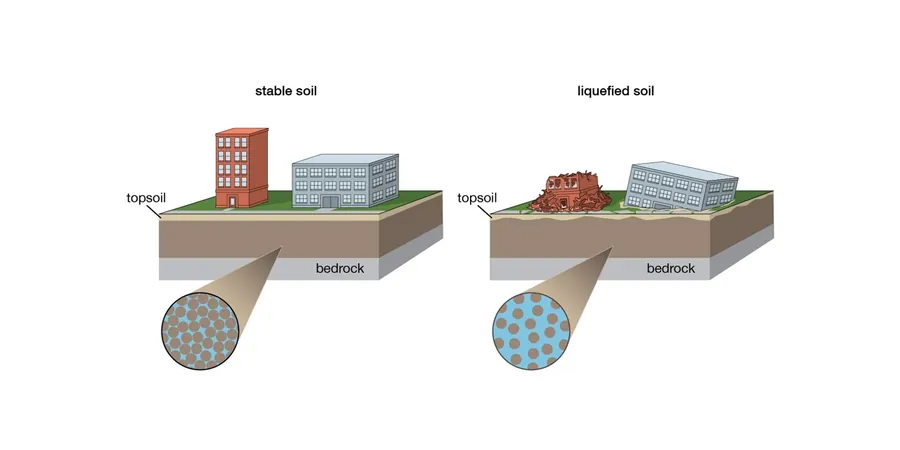
Methodology and scope
Local considerations
The El Paso-Ciudad Juárez metropolitan area sits within the Rio Grande rift, a tectonically active extensional basin with Quaternary faults mapped less than 15 kilometers east of downtown. The basin fill reaches thousands of feet thick in places, but the upper 30 to 50 feet—the zone that drives liquefaction hazard—is predominantly Late Pleistocene to Holocene arroyo deposits. These sands and silts were laid down during flash flood events and reworked by lateral channel migration, so vertical continuity is rare; a three-foot bed of clean sand can pinch out laterally within a block. That stratigraphic chaos means you cannot just run one SPT boring and extrapolate across the site. When the water table sits within 20 feet of the surface, as it does seasonally along the river corridor and near irrigation-fed zones in the Lower Valley, even a magnitude 5.5 event 100 miles away can generate enough cyclic shear stress to trigger pore-pressure buildup. We have seen samples from projects near Ascarate Park where the combination of high silt content and low plasticity fooled the SPT-based screening, but the laboratory cyclic testing confirmed marginal resistance. Ignoring those nuances leaves a building code-compliant structure sitting on a time bomb.
Explanatory video
Applicable standards
IBC 2021 Section 1803.5 – Seismic Design Category D site investigation requirements, ASCE 7-22 Chapter 11 – Liquefaction triggering analysis procedures, ASTM D1586-18 – Standard Test Method for Standard Penetration Test (SPT), ASTM D6913/D6913M-17 – Particle-Size Distribution (Gradation) of Soils Using Sieve Analysis, ASTM D4318-17e1 – Liquid Limit, Plastic Limit, and Plasticity Index of Soils, NCEER/NSF Workshop on Evaluation of Liquefaction Resistance (Youd & Idriss, 2001)
Associated technical services
Index Testing for Screening
We run grain-size distribution and Atterberg limits on every sample from potentially liquefiable depths. These two tests filter out soils that fall outside the susceptibility window before you spend budget on advanced cyclic testing.
Cyclic Triaxial Testing
When SPT-based screening places a layer in the marginal zone, we perform stress-controlled cyclic triaxial tests per ASTM D5311 to measure the actual number of cycles to liquefaction at the project’s design CSR.
Post-Liquefaction Settlement Estimate
Using the volumetric strain correlations from Ishihara and Yoshimine (1992) and our measured relative density data, we calculate the expected ground-surface settlement to guide foundation decisions.
Typical parameters
Frequently asked questions
Does El Paso really have a liquefaction risk given its desert climate?
It surprises a lot of people, but yes. The shallow groundwater along the Rio Grande corridor and in irrigated agricultural areas of the Lower Valley creates saturated soil conditions within 15 to 25 feet of the surface. Combine that with loose alluvial sands deposited by the river and arroyo floods, and you have the ingredients for liquefaction during a moderate to large earthquake on the East Franklin fault or a distant event like the 1887 Bavispe quake.
What is the typical cost range for a liquefaction analysis on a commercial lot in El Paso?
For a standard commercial lot requiring a few SPT borings, laboratory index testing, and the engineering analysis, costs generally run between US$2,310 and US$4,660. The final number depends on how many samples need cyclic triaxial testing and whether we have to run hydrometer analyses on high-fines material.
How many borings do you need for a reliable liquefaction assessment?
The IBC requires at least one boring for every 2,500 square feet of building footprint in Seismic Design Category D, but for liquefaction we typically recommend a minimum of two to three borings even on smaller sites. The alluvial deposits here can change from clean sand to silty sand in less than 50 feet laterally, so a single boring gives a dangerously narrow picture.
Do you use SPT or CPT data for the liquefaction triggering analysis?
Both methods are valid under the NCEER consensus framework, but here in El Paso the standard penetration test remains the workhorse because our gravelly alluvial layers often make CPT refusal a problem. We apply the Seed-Idriss simplified procedure with the NCEER (Youd & Idriss 2001) updates, correcting blow counts for overburden, hammer energy, and fines content measured in our lab.